Adding a Map
You can configure the address information to be displayed in a map, in Details view, by adding an additional panel to the Details control.
There are two options to show items on a map:
- Based on geo-coordinate fields. These fields must first be added to the Aurea CRM data
model, see the Aurea CRM win Administrator Guide. Note: Aurea recommends that you always provide the latitude and longitude fields to capture the geographic coordinates. This is especially useful if you wish to show all annotations in a map, see Showing All Annotations in a Map.
- Based on an address.
Configuring either option is almost identical:
- Add a panel to the desired Details control and assign the
MAPtype. - Add the Longitude (x) and Latitude (y)
fields for the two geo-coordinates.
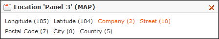
Note: You must enter the Longitude (x) field before the Latitude (y) field. If you want to show the records based on the address instead, you need not add the geographic coordinate fields, you can add two dummy fields (e.g. FreeDec1 and FreeDec2) as placeholders instead. - Add a field that is used as header text in the Map view. For example, the Company field.
- Add the address fields:
- If you use the geo coordinate fields, the address is displayed below the header text.
- If you display the address based on the address fields, they must be added to the panel. It is best practice to add the Street, ZIP and City fields and then combine them, see Combining Field Values.
Note:
Apple-Geocoder cannot display addresses correctly that contain a hyphen and spaces in the building's number. For example, the address Operngasse 17 - 21 is only displayed correctly when it is entered in the database without spaces: Operngasse 17-21.